")
Get ready to navigate the region like never before with our new multimodal map, the Northwest Navigator. Curated exclusively for the northwest metro region, the map will help you plan your next journey using any mode. This map brings together all transportation options in one place, making it easy to see how different modes connect and how to use them to get where you need to go.
Commuting Solutions, in partnership with the City and County of Broomfield, Longmont, Boulder, Boulder County, Louisville, Superior, Erie, Lafayette and Westminster, have launched this one-of-a-kind, multimodal, online map, to make multimodal travel through the region easier than ever. Argis Solutions, Inc., a Colorado based geospatial consultancy, provided GIS development expertise and project coordination for this effort. The firm specializes in delivering GIS services to nonprofits and local governments (learn more at www.argis.com).
Featuring the same data as our popular Bike Northwest Map, along with additional assets such as transit routes, Bike-n-Ride shelter locations, microtransit, bikeshare and more, the Northwest Navigator makes planning your next work commute, recreational trip, or weekend ride a breeze.
What’s Included?
The Northwest Navigator utilizes several “Map Layers,” which you can turn on and off based on your preferred modes of transportation.
Bicycle
Building on the Commuting Solutions popular Bike Northwest Map, the Northwest Navigator includes bike routes and path types, along with Bike-n-Ride shelter locations and Boulder B-cycle kiosks for a more complete commute-planning experience.
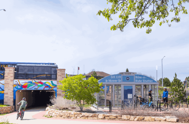
- Bike-n-Ride Shelters: RTD Bike-n-Ride shelters offer secure, covered bike parking at select RTD stations to support easy first- and last-mile connections. Register for a complimentary access card at [link].
- Boulder B-Cycle Kiosks: Boulder B-cycle is a local bike-share program offering shared bikes at kiosk stations across Boulder for residents, workers, and visitors.
- Bicycling Facilities: The Northwest Navigator displays all bicycle facilities and highlights the type of bicycle infrastructure used along each path.
RTD Transit
The Northwest Navigator allows you to view everything related to RTD transportation services and helps highlight RTD connectivity across the region.
- US 36 Flatiron Flyer Stations and Routes: The RTD Flatiron Flyer is a bus rapid transit (BRT) service that provides frequent, reliable trips between Boulder, Denver, and stops along the US 36 corridor.
- RTD Transit Stops, Routes and Park-n-Rides: Easily find nearby RTD bus stops and transit stations to connect with your community by transit.
- RTD FlexRide Areas: On-demand or call-ahead service that will take you from a transit stop to your final destination. FlexRide service is included in a general bus fare ticket.
Transfort FLEX
The Tansfort FLEX provides service between Fort Collins, Loveland, Longmont and Boulder.
Seasonal Transit Services
- Hessie Shuttle: Provides weekend shuttle service that takes you to multiple hiking trails in the Indian Peaks Wilderness, west of Nederland, CO.
- Eldo Shuttle: Free shuttle bus service on weekends and holidays during the summer and fall from US 36 & McCaslin and Boulder to Eldorado Canyon State Park and other popular trailheads.
- Park-to-Park Chautauqua Shuttle: Shuttle service between Boulder and Chautauqua Park.
- Bustang to Estes Park & RMNP: Service between Denver and Rocky Mountain National Park, with stops in Boulder and Estes Park
CU Boulder Buff Bus
The CU Buff Bus service at CU Boulder provides free transportation between Main Campus, East Campus, and Williams Village/Bear Creek. Also features stops for the on-demand Buff Ride with designated stops on the Main and East Campuses.
Microtransit
- Ride Free Lafayette: Free, on-demand, door-to-door bus service that connects people to place in the City of Lafayette.
- Ride Longmont: On-demand transit service for $2 or less within the City of Longmont
Other
- Gold Hill Climb: Free service between Boulder and Gold Hill.
- Mountain Rides: Free service between Ward and Rollinsville, stops in Nederland.
- Lime Scooter Corrals: The location of designated parking zones for electric Lime Scooters.
Using the Northwest Navigator
The Northwest Navigator uses interactive map layers to help you navigate using the travel options that work best for you. Simply navigate to your desired location and find multimodal transportation options near you. Turn layers on or off, and watch the map adjust in real time.
")
Step 1: Use the “Map Layers” to select your travel modes
Step 2: Select your favorite “Basemap Gallery.” Select a style that fits your needs.
Step 3: Explore travel options by entering your desired location and turning on and off “Map Layers.”
Step 4: Select the “Print” icon to save routes as a PDF that you can download and print.
Start Exploring the Northwest Navigator
The Northwest Navigator brings the region’s transportation options together in one easy-to-use, interactive map, making it simpler than ever to plan trips that fit your lifestyle. Whether you’re biking to work, catching transit to campus, heading out for a weekend hike, or trying a new way to get around, the Northwest Navigator helps you discover convenient, connected, and sustainable travel options across the northwest metro region.
Explore the map, turn on the layers that matter most to you, and see how easy it can be to navigate your community without relying on a single mode of transportation. Visit the Northwest Navigator today and start planning your next trip with confidence.
Have questions about the map, please contact us at info@commutingsolutions.org.